MIDWAY LOGBOOK
Midway's Beginnings
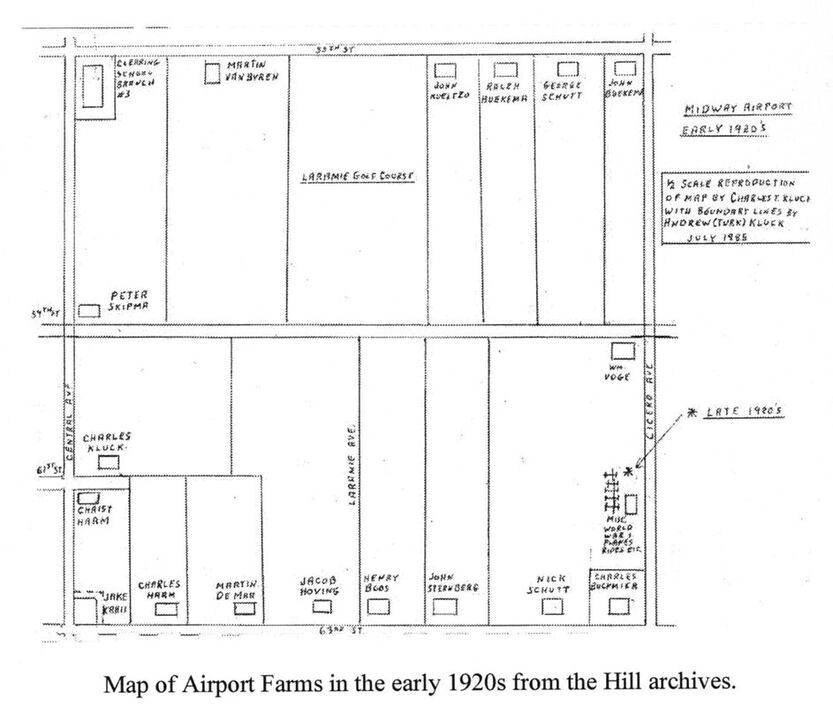
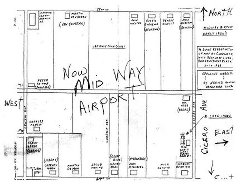
Shown below this narrative are two diagrams or maps. One was drawn up by Andrew "Turk" Kluck, son of early "Midway farmer" Charles Kluck. The other is a hand-drawn version of the same map, received from a gentleman named Martin Stulp who had purchased the book Midway Airport. Marty, who is 84, shared some history about the airport's beginnings – particularly since he is originally from the Clearing area and is friends with Arnold Hoving, a relative of one of one of those who farmed on the land Midway is now situated upon.
Robert M. "Moose" Hill's book, "A Little Known Story of the Land Called Clearing" contains the original Charley Kluck diagram of the farms located on "Section 16", the technical name for the Midway Mile. Moose's book is an excellent history of the Clearing area, including Midway. Much of what I've heard about the airport's truck farmers, who dotted the mile, was garnered from Moose's written accounts and my interviews with him.
In his wonderful book, Moose writes of the entire region's beginnings, including the presence of vast populations of Indians in the 1700s. But aside from the notes in his book about the area's truck farmers, not much is known about those who rented land on the "Midway Airport Mile." My correspondence from Marty Stulp helped add to the history.
A Little More About Midway's Beginnings
If you read the earliest history, the Land Ordinance of 1785 and the Northwest Ordinance of 1787 eventually resulted in the birth of townships in designated regions. To make a long and really interesting history even longer, in certain regions of the country land was surveyed into square townships, six miles on a side. Each township was subdivided into thirty-six sections of one square mile or 640 acres per section. These sections could then be further subdivided for re-sale.
The land that Midway Airport occupies was originally known as a "school section," and it is also designated as Section 16 of the 36-square-mile township in which it resides. Section 16 of each township was the standard school section (square mile) and served primarily to maintain public schools. Other activities were also permitted on school sections and a portion of the monies garnered from renters of a given parcel of land helped fund public education. The Midway Mile was no exception: before the Midway we know of today, there were two taverns, two schoolhouses, a golf course and eighteen truck farms.
And, of course, there was the C&WI Railroad’s right-of-way down 59th street, bisecting the mile until mid-1941.
I don't have all the details but Moose related to me that municipal records show the Village of Clearing as claiming possession of the southern half of Section 16, and Stickney Township as claiming possession of the northern half. I don't know how that works, but it surely makes for an interesting story. Word and some data have it that “Long John” Wentworth owned large parcels of land around the Midway Mile.
The bulk of this history is contained in an expanded version of Moose Hill's 1983 edition of "Clearing" and the recent, exhaustive Second printing is readily available as a paperback through the Clearing-Garfield Ridge Historical Society.
Many aren't aware of this, but the land Midway is on was leased from the Board of Education until it was purchased by the City of Chicago in 1982. Marty Stulp tells me that he was told the land was purchased from the Board for one dollar. I don't know if that story's true, but based on other stories I've heard, it won't have been the first time Chicago made a killing on a land deal.
The diagrams give away several interesting things: One, all the names are Dutch names. Marty said that they were all very hard-working and industrious immigrants who came over in the late-1800s. You'll notice that some of the names are "corrected". I didn't change anything on these diagrams from how they appeared in Turk Kluck's original drawing -- the edits are the work of Arnold Hoving, former superintendent of Timothy Christian Schools, grandson of John Sterenberg (a farmer on the mile) as well as a good friend of Marty's. Arnold sent Marty this (corrected) map, so I have him to thank also.
Finally, the maps show the location of Clearing School at Central near 55th. It was succeeded by the Nathan Hale Elementary School a mile away, just off 63rd Street, when the "Airport Hale School" opened in 1926. Some may wonder why there were schools at all on the Midway mile, but it was not always the Midway mile. Besides, for eight years I attended a grade school adjacent to the (short) final approach of a busy, popular suburban airport and nobody thought much of it. Safety wasn’t an issue for Hale students like Robert “Moose” Hill — identifying the airplanes was. Likewise, it was hard for me as a grade school student to concentrate on schoolwork when I could tell who was flying on any given day. You could also tell who had just smanged their bird, too, because of the close proximity of the school to the airfield. It was the same way with Hale School students when Midway was in full swing, I’m sure. Moose kept incredibly accurate records of each and every pranger.
One of those Dutch farm families from Midway was directly related to the family of Wayne Huizenga, who began Waste Management, Blockbuster Video, AutoNation and Swisher Hygiene.
I understand that some 18 truck farmers leased land, farmed and resided on the airport. The maps show the location of each plat and also show errata: the names Charles Kluck, Van Beveren and a few other of those Dutch names needed correction. One that escaped notice even on the corrected map is Charles Buckmeier, who owned Buckmeier’s Tavern on 63rd Street and Cicero Avenue. The other tavern, Al Marshall’s, was known as Al Marshall’s Store and sold school supplies and other items. Every year there were contests for students who purchased school supplies and fine prizes. Art Hill, Moose’s brother, still has a nicely decorated metal box that held candy prizes he won. Al Marshall’s Store was later relocated off-airport, across Central Avenue.
Marty Stulp also told me that the farmers used to walk to 13th and Ashland every Sunday morning to the Dutch Reformed church there, until one was built closer to their farms. These were not lonely stalwart men and families with deep-seeded work and life ethic, they were also people of great faith.
I have more detail than I'm sharing here but that's only because my conversation with Marty was long and full of stories. If you have any questions or feedback, please send them along via email (see "Contact Us below), and I will relay your questions to Marty. He, in turn, will ask Arnold Hoving, whom he sees on a fairly consistent basis.
Dave Kent
Copyright ©2009-2020 The Midway Historians. All rights Reserved


